
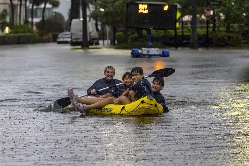
A tropical disturbance has triggered a rare flash flood emergency across southern Florida, with residents preparing for more heavy rainfall on Thursday and Friday.
Wednesday’s torrential downpours and subsequent flooding obstructed roads, stranded vehicles, and delayed the Florida Panthers en route to their Stanley Cup games in Canada against the Edmonton Oilers.
This disorganized storm system moved across Florida from the Gulf of Mexico, coinciding with the early June start of hurricane season. This year’s season is predicted to be one of the most active in recent years, with concerns that climate change is intensifying storms.
The disturbance has not yet reached cyclone status and has only a slight chance of forming into a tropical system once it reaches the Atlantic Ocean after crossing Florida, according to the National Hurricane Center.
The National Weather Service in Miami announced on social media platform X early Thursday that another band of heavy rainfall was expected to hit the region for the third consecutive day.
“Even a brief period of heavy rainfall could lead to more flash flooding!,” the post warned.
Numerous roads remained flooded and impassable. On Interstate 95 in Broward County, southbound traffic was diverted around a flooded section, and contractors were en route to pump the drainage system, according to an email from the Florida Highway Patrol. The interstate will not reopen until the water is drained.
The Miami weather service office issued increasingly urgent warnings.
“Life-threatening flooding is now occurring,” the service stated on platform X. “Please stay off the roadways and move to higher ground.”
The mayors of Fort Lauderdale and Hollywood declared a state of emergency for their cities on Wednesday afternoon. Later that day, Florida Governor Ron DeSantis also declared a state of emergency for five counties, including Broward and Miami-Dade on Florida’s Atlantic coast and Collier, Lee, and Sarasota counties on the state’s west coast. Miami-Dade County Mayor Daniella Levine Cava also issued a local state of emergency.
In nearby Hollywood, Mike Viesel was driving home with his dog Humi on Wednesday afternoon when he was caught in deep floodwater along a low-lying street, he told the Miami Herald.
As he slowed down and stopped, Viesel said other cars drove past him, pushing even more water into his vehicle and causing his engine to stall.
“I’d walk out of my car,” he told the Herald, but his dog “has a problem with water.”
In Miami’s Edgewater neighborhood, the lobby of the building that Alfredo Rodriguez moved into a year ago was already flooded on Wednesday morning. He told the Herald that the building has flooded five times since he moved in.
“This is horrible. I can’t pull my car around,” he said of the flooded streets.
Dozens of flights were delayed or canceled at Fort Lauderdale-Hollywood International Airport. The NHL’s Florida Panthers were delayed more than three hours from departing Fort Lauderdale for their nearly six-hour flight to Edmonton for Games 3 and 4 of the Stanley Cup Final.

Farther north, the National Weather Service in Melbourne confirmed that an EF-1 tornado hit Hobe Sound on Florida’s Atlantic Coast north of West Palm Beach on Wednesday morning.
The winds knocked down multiple banyan trees and caused some damage to a store, Martin County Fire Rescue officials said. No injuries were reported, but access to wealthy Jupiter Island was cut off by debris on the road.
It’s already been a wet and blustery week in Florida. In Miami, about 6 inches (15 centimeters) of rain fell Tuesday and 7 inches (17 centimeters) in Miami Beach, according to the National Weather Service. Hollywood got about 5 inches (12 centimeters).
Brian McNoldy, a senior research associate at the University of Miami Rosenstiel School, noted on X that some 9 inches (23 centimeters) had fallen on parts of South Florida from 7 a.m to 6 p.m. on Wednesday in addition to the rain that fell on Tuesday.
More rain was forecast for the rest of the week, leading the weather service office in Miami to extend a flash flood watch through Thursday. Some places could see another 6 inches (15 centimeters) of rain.
The western side of the state, much of which has been in a prolonged drought, also received significant rainfall. Nearly 6.5 inches (16.5 centimeters) of rain fell Tuesday at Sarasota Bradenton International Airport, the weather service said, and flash flood warnings were in effect in those areas as well.
Forecasts predict an unusually busy hurricane season.
The National Oceanic and Atmospheric Administration estimates there is an 85% chance that the Atlantic hurricane season will be above average, predicting between 17 and 25 named storms in the coming months, including up to 13 hurricanes and four major hurricanes. An average season has 14 named storms.


![Sheikh Khalifa Bin Zayed Al Nahyan Director Mr. Hamis Mohamed (center), ARR Insurance Coast Regional Manager Julie Gaitho (right), AAR Insurance Group Head of Technology Eugene Sanya (left) and students of Al Nahyan participate in planting part of 40,000 trees at the school's compound to mark AAR' 40th anniversary. [Joackim Bwana, Standard]](https://i0.wp.com/cdn.standardmedia.co.ke/images/wysiwyg/images/hnjuNIZaLG82LriAD53nnZAgR18w68QTikMsXCWC.jpg?w=1200&resize=1200,0)


")